Introduction to hydrogeology and ArcGIS applications
Online course |
|
60 hours / 6 weeks |
|
Dates: to be determined |
Full licenses for ArcGIS Desktop (ArcMap) + Extensions for 1 year!
Introduction
The course “Introduction to hydrogeology and ArcGIS applications” has been created for undergraduates, graduates, juniors, geologists, and hydrogeologists worldwide in order to provide them with the complete knowledge that will allow them to understand the subtle interactions that occur within the Earth and result in the creation and shaping of aquifers. To understand the formation of groundwater bodies, one must firstly understand the dynamic nature of Earth, geostructural formations and the chemistry that occurs.
Upon completion of the course, the participants will gain sufficient knowledge that will allow them to logically analyse and understand the macro and micro factors that shape the “hidden world” of groundwater systems. It is a beautiful world and one that is becoming of crucial importance for the development and sustainability of any civilization. Water is the new oil and as such, it must be kept safe and used in accordance with the principles of sustainable development.
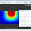
The second part of the course will dive into ArcGIS modelling and the course will cover not only hydrogeology applications but also wider, geology related mapping and analysis (because the two cannot be divided). We will go through cartography, rasters, and 3D modelling in ArcGIS. We will also go through Autocad and Groundwater Vistas. The course aims to provide knowledge which can be used and not merely knowledge per se, so modelling will be oriented towards real examples and precision.
The licenses will be for one year, full, commercial licenses for ArcGIS Desktop (ArcMap) and Extensions
Limited places.
-
Module 1 – 8 hours
-
The importance of groundwater
-
Hydrological systems and groundwater
-
Formation of groundwater systems
-
Porosity and effective porosity
-
Principles of groundwater flow
-
Flow in groundwater systems
-
Understanding the stratigraphy of the cross-section and types of aquifers that may occur.
-
-
Module 2 – 10 hours
-
Groundwater balance concepts
-
Groundwater balance estimation methods
-
Groundwater balances and their environment
-
Groundwater and its interaction with rocks
-
Groundwater chemistry and rock types
-
Development of groundwater aquifers – Definition, Recharge and Discharge Areas, Aquifer Transmissivity and Storage, Types of Aquifers, Aquifer Parameters and Methods of Determination, Aquifer Recharge and Sustainability, Managed Aquifer Recharge (MAR) and Aquifer Storage and Recovery (ASR)
-
Springs and Spring Development, Underground Dams, Competent and Leaky Aquitards
-
The forming of karst aquifers.
-
-
Module 3 – 10 hours
-
Groundwater extraction – Vertical Wells, Collector Wells and Horizontal Wells, Infiltration Galleries and Drains
-
Source Water Protection Zones
-
Groundwater contamination – Regulations, sources of contamination and contaminants, drinking water standards and emerging contaminants
-
Transport of contaminants – Free Phase and Residual Phase Contamination, Dissolved Phase Contamination, Dispersion, Diffusion, Sorption, Degradation
-
-
Module 4 – Cartography and ArcGIS – 12 hours
-
What is GIS – 30 minutes
-
Georeferencing – the first step – 30 minutes
-
ArcCatalog and creating a database – 1 hour
-
Editing mode – drawing a map – polygons, lines, and points. – 8 hours
-
Labelling, colors, exporting. – 2 hours
-
Autocad profile creation – 2 hours
-
-
Module 5 – 12 hours
-
Working with rasters
-
Watershed and Stream Network Delineation based on a DEM analysis.
-
Determining the vulnerability of groundwater – GLA
-
-
Module 6 – 10 hours
-
Determining the vulnerability of groundwater – DRASTIC method
-
Determining the vulnerability of groundwater – EPIC method
-
Introduction to Groundwater Vistas. – 1 hour
-
A glimpse of 3D modeling in ArcGIS – 1 hour
-
Matija Kordic
Master in Engineering and Bachelor of Engineering Geology with a specialty in Hydrogeology from the University of Belgrade, Faculty of Mining and Geology.
Created a hydrogeology map of Zlatibor County, Republic of Serbia. For his master thesis, analysed the current National Strategy of Sustainability and Water Management for Central Serbia and suggested a more sustainable approach, based on groundwater exploitation and ArcGIS applications. His experience includes groundwater management, karst aquifers specialization, and ArcGIS analysis.
He is currently working as an engineer of hydrogeology for HydroGeoEco and as an independent ArcGIS analyst consultant for numerous firms doing 3D modelling, modelling, analysis and ideation.
He is author of two peer-reviewed journal articles, and is currently writing two books. The journal articles were related to engineering and management of karst aquifers and water accumulations.
All of our courses are offered 100% online, through our intuitive Virtual Campus. Topics are taught through:
- – Videos
- – Interactive multimedia content
- – Live classes
- – Texts
- – Case studies
- – Evaluation exercises
- – Additional documentation
The content is updated in each new course edition, so that knowledge is acquired around the latest news and state-of-the-art geotechnical engineering technology.
One of the most interesting aspects of our courses is the use of live videoconferences, in which teachers and students interact in a continuous exchange of knowledge and problem solving. In addition to this, students can make use of the platform’s forum, a meeting point where they can interact with teachers and other students.
A tutoring system will also be established by email, which will resolve any possible doubts about the course, and which will serve as a point of connection for students with specific questions on each module.
Students can also download all course documentation, including texts, videos, video conferences and exercises.
Undergraduates, graduates, juniors, geologists, and hydrogeologists worldwide.
At the end of the course, and as accreditation of knowledge acquired and of the technical and practical training, students who correctly complete the corresponding evaluation tests of the geotechnical engineering course will obtain an academic certificate issued by Ingeoexpert. This digital certificate is protected by Blockchain technology, making it unique and tamper-proof, thus enabling companies to verify its authenticity.
It can also be downloaded by students, forwarded by email and shared on social networks, as well as embedded on any website. You can see an example here.
- Hydrogeology engineering
- Geology engineering
- Geology
- ArcGIS analyst
- Water Resources management
- Environmental engineering
- Cartography
Full licenses for ArcGIS Desktop (ArcMap) + Extensions for 1 year!
Introduction
The course “Introduction to hydrogeology and ArcGIS applications” has been created for undergraduates, graduates, juniors, geologists, and hydrogeologists worldwide in order to provide them with the complete knowledge that will allow them to understand the subtle interactions that occur within the Earth and result in the creation and shaping of aquifers. To understand the formation of groundwater bodies, one must firstly understand the dynamic nature of Earth, geostructural formations and the chemistry that occurs.
Upon completion of the course, the participants will gain sufficient knowledge that will allow them to logically analyse and understand the macro and micro factors that shape the “hidden world” of groundwater systems. It is a beautiful world and one that is becoming of crucial importance for the development and sustainability of any civilization. Water is the new oil and as such, it must be kept safe and used in accordance with the principles of sustainable development.
The second part of the course will dive into ArcGIS modelling and the course will cover not only hydrogeology applications but also wider, geology related mapping and analysis (because the two cannot be divided). We will go through cartography, rasters, and 3D modelling in ArcGIS. We will also go through Autocad and Groundwater Vistas. The course aims to provide knowledge which can be used and not merely knowledge per se, so modelling will be oriented towards real examples and precision.
The licenses will be for one year, full, commercial licenses for ArcGIS Desktop (ArcMap) and Extensions
Limited places.
-
Module 1 – 8 hours
-
The importance of groundwater
-
Hydrological systems and groundwater
-
Formation of groundwater systems
-
Porosity and effective porosity
-
Principles of groundwater flow
-
Flow in groundwater systems
-
Understanding the stratigraphy of the cross-section and types of aquifers that may occur.
-
-
Module 2 – 10 hours
-
Groundwater balance concepts
-
Groundwater balance estimation methods
-
Groundwater balances and their environment
-
Groundwater and its interaction with rocks
-
Groundwater chemistry and rock types
-
Development of groundwater aquifers – Definition, Recharge and Discharge Areas, Aquifer Transmissivity and Storage, Types of Aquifers, Aquifer Parameters and Methods of Determination, Aquifer Recharge and Sustainability, Managed Aquifer Recharge (MAR) and Aquifer Storage and Recovery (ASR)
-
Springs and Spring Development, Underground Dams, Competent and Leaky Aquitards
-
The forming of karst aquifers.
-
-
Module 3 – 10 hours
-
Groundwater extraction – Vertical Wells, Collector Wells and Horizontal Wells, Infiltration Galleries and Drains
-
Source Water Protection Zones
-
Groundwater contamination – Regulations, sources of contamination and contaminants, drinking water standards and emerging contaminants
-
Transport of contaminants – Free Phase and Residual Phase Contamination, Dissolved Phase Contamination, Dispersion, Diffusion, Sorption, Degradation
-
-
Module 4 – Cartography and ArcGIS – 12 hours
-
What is GIS – 30 minutes
-
Georeferencing – the first step – 30 minutes
-
ArcCatalog and creating a database – 1 hour
-
Editing mode – drawing a map – polygons, lines, and points. – 8 hours
-
Labelling, colors, exporting. – 2 hours
-
Autocad profile creation – 2 hours
-
-
Module 5 – 12 hours
-
Working with rasters
-
Watershed and Stream Network Delineation based on a DEM analysis.
-
Determining the vulnerability of groundwater – GLA
-
-
Module 6 – 10 hours
-
Determining the vulnerability of groundwater – DRASTIC method
-
Determining the vulnerability of groundwater – EPIC method
-
Introduction to Groundwater Vistas. – 1 hour
-
A glimpse of 3D modeling in ArcGIS – 1 hour
-
Matija Kordic
Master in Engineering and Bachelor of Engineering Geology with a specialty in Hydrogeology from the University of Belgrade, Faculty of Mining and Geology.
Created a hydrogeology map of Zlatibor County, Republic of Serbia. For his master thesis, analysed the current National Strategy of Sustainability and Water Management for Central Serbia and suggested a more sustainable approach, based on groundwater exploitation and ArcGIS applications. His experience includes groundwater management, karst aquifers specialization, and ArcGIS analysis.
He is currently working as an engineer of hydrogeology for HydroGeoEco and as an independent ArcGIS analyst consultant for numerous firms doing 3D modelling, modelling, analysis and ideation.
He is author of two peer-reviewed journal articles, and is currently writing two books. The journal articles were related to engineering and management of karst aquifers and water accumulations.
All of our courses are offered 100% online, through our intuitive Virtual Campus. Topics are taught through:
- – Videos
- – Interactive multimedia content
- – Live classes
- – Texts
- – Case studies
- – Evaluation exercises
- – Additional documentation
The content is updated in each new course edition, so that knowledge is acquired around the latest news and state-of-the-art geotechnical engineering technology.
One of the most interesting aspects of our courses is the use of live videoconferences, in which teachers and students interact in a continuous exchange of knowledge and problem solving. In addition to this, students can make use of the platform’s forum, a meeting point where they can interact with teachers and other students.
A tutoring system will also be established by email, which will resolve any possible doubts about the course, and which will serve as a point of connection for students with specific questions on each module.
Students can also download all course documentation, including texts, videos, video conferences and exercises.
Undergraduates, graduates, juniors, geologists, and hydrogeologists worldwide.
At the end of the course, and as accreditation of knowledge acquired and of the technical and practical training, students who correctly complete the corresponding evaluation tests of the geotechnical engineering course will obtain an academic certificate issued by Ingeoexpert. This digital certificate is protected by Blockchain technology, making it unique and tamper-proof, thus enabling companies to verify its authenticity.
It can also be downloaded by students, forwarded by email and shared on social networks, as well as embedded on any website. You can see an example here.
- Hydrogeology engineering
- Geology engineering
- Geology
- ArcGIS analyst
- Water Resources management
- Environmental engineering
- Cartography
More info
Finish this course and get a certificate based on Blockchain
Introduction to hydrogeology and ArcGIS applications
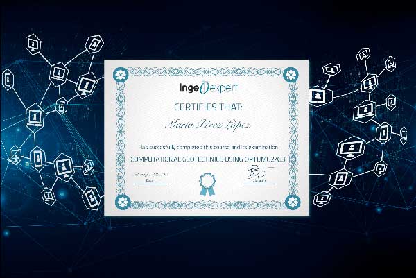
Blockchain technology makes the certificate incorruptible, enabling companies to verifiy its autenticity.
Reviews
There are no reviews yet.