
Geostatistics for exploration and mining
Online course |
|
50 hours / 6 weeks |
|
To be determined |
Introduction
This course is designed to provide a solid theoretical foundation for all aspects of statistics applied to mineral exploration and mining. It will also give clear pointers of the practical significance of all factors and concepts discussed, with the help of real-world geological examples.
Particular attention will be given to the extrapolation of available sample data to the whole population, with specific emphasis on single variable inference, correlation inference, and point and block estimation. Important concepts and techniques, such as weighted mean, multivariable analyses, and Kriging, will be presented and discussed. Special emphasis will be placed on the spatial data description, visualization, and estimation. Significant space will be devoted to effective data presentation and visualization methods, in particular spatially-defined data, but also of single variable.
All the necessary mathematical concepts will be presented and discussed at appropriate detail, rooting this course in statistics theory and providing the essential background that will help students apply this knowledge in the real world of exploration and mining.
Objectives
The main objective of this course is to introduce the fundamental geostatistical concepts and applications, together with their mathematical formulations. The students will gain a solid grounding in the essential ideas, principles, and concepts of applied geostatistics, including single variable, two variables, multivariable analysis, spatial statistics, and point and block estimation. The students will be able to select the most appropriate methods for their own applications and make the best possible inferences for their exploration or mining purposes.
There will be two live meetings per week (via BlueJeans), on Monday and on Friday at 10 to 10:40 am CST.
Limited places.
This course will be organized in 6 units. For each unit, there will be a chapter in the course manual for each unit, as well as a video lecture.
Unit 1. Introduction and preliminary considerations
– 1.1. The purpose and nature of Geostatistics
– 1.2. The nature of geochemical data
– 1.3. General concepts
– 1.4. Data representation and data visualization
– 1.5 Sampling
Unit 2. Single variable
– 2.1. Data visualization: histograms
– 2.2. Measures of location and of dispersion
– 2.3. Visualization of location and dispersion
– 2.4. Definition of anomaly and of sub-samples
– 2.5. Prediction of population from a sample
– 2.6. Confidence interval estimation
– 2.7. Weighted mean
Unit 3. Two variables
– 3.1. Data visualization: scatterplots
– 3.2. Linear regression and quantifying it
– 3.3. Non-linear regressions
– 3.4. Quantifying the variability of the linear regression
– 3.5. Inferences using the regression line
– 3.6. The coefficient of determination
– 3.7. The correlation coefficient and its significance
Unit 4. Multivariable analysis
– 4.1. The need for and purpose of multivariable analysis
– 4.2. Different types of multivariable analysis
– 4.3. Correlation tables
– 4.4. Principal component analysis
Unit 5. Spatial representation
– 5.1. The need and particularities of spatial representation
– 5.2. Stationarity of the mean and of the variance
– 5.3. Different types of spatial representation
Unit 6. Estimation of unknown location
– 6.1. Methods of estimation
– 6.2. Variograms
– 6.3. Kriging
Paul Alexandre
Dr. Paul Alexandre is an experienced exploration geochemist and academic who uses geostatistics extensively and is highly proficient and competent in it. He has taught this and other courses in both the academic and industry settings, in Canada, France, and elsewhere.
The course is delivered online through our easy-to-use Virtual Campus platform. For this course, a variety of content is provided including:
– eLearning materials
– Videos
– Interactive multimedia content
– Live webinar classes
– Texts and technical articles
– Case studies
– Assignments and evaluation exercises
Students can download the materials and work through the course at their own pace.
We regularly update this course to ensure the latest news and state-of-the-art developments are covered, and your knowledge of the subject is current.
Live webinars form part of our course delivery. These allow students and tutors to go through the course materials, exchange ideas and knowledge, and solve problems together in a virtual classroom setting. Students can also make use of the platform’s forum, a meeting point to interact with tutors and other students.
The tutoring system is managed by email. Students can email the tutor with any questions about the course and the tutor will be happy to help.
There will be two live meetings per week (via BlueJeans), on Monday and on Friday at 10 to 10:40 am CST.
This course is designed for anyone who needs geostatistics for their work, regardless of the types of application, and for both the academic-based and the industry-based geoscientists. It is suitable for upper level undergraduate students, graduate students, and early-career exploration and mining geologists.
Once a student finishes the course and successfully completes the assignments and evaluation tests, they are sent an accreditation certificate. The certificate is issued by Ingeoexpert to verify that the student has passed the course. It is a digital certificate that is unique and tamper-proof – it is protected by Blockchain technology. This means it is possible for anyone to check that it is an authentic, original document.
You will be able to download the certificate in an electronic format from the Virtual Campus platform. The certificate can be forwarded by email, shared on social networks, and embedded on websites. To see an example, click here.
This course is highly beneficial to anyone who intends to work in the exploration or mining industry, but also for any early-career geoscientist dealing with a significant amount of numerical data. This course will provide any geologist with the required background to work in domains such as resource estimation, exploration targeting, and deposit characterization.
8 reviews for Geostatistics for exploration and mining
More info
Finish this course and get a certificate based on Blockchain
Geostatistics for exploration and mining
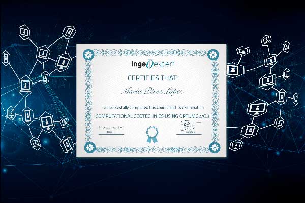
Blockchain technology makes the certificate incorruptible, enabling companies to verifiy its autenticity.
Carel Burger –
Great personal interaction and flexible timelines to fit our needs to do this course part time. Wonderful feedback and truly easy and user friendly platform.
Vaino Shanyengana Shihepo –
I love the way the course is structured and delivered. Course materials were clear and helpful. The professor is good and always willing to help. He also gives clear practical examples thereby enabling students to always relate and have in-depth understanding of the subject
Alexandrin Dicu –
I highly recommend the “Geostatistics for Exploration and Mining” course. The course modules are explained in detail and answers and explanations have been provided to all questions. Dr. Alexandre is providing a continuous feedback to any query raised, which is improving the participant understanding related to the course.
Keobametse Phiri –
The lectures has complete control of releasing material like in a normal learning class. That promote a progressive move and understanding, like in a normal class.
Marcilio Rocha –
This course is really well structured and content is great. Highly recommended.
Felice Mutimhodyo –
I loved the way professors teach, the elaborations and explanations were on another level.
OUFSSA Rachid –
I really enjoyed the way the course was structured and the quality of the modern learning platform. The teaching approach of the professors was excellent and reflected true passion for their work.
Felice Mutimhodyo –
I loved the way professors teach, the elaborations and explanations were on another level.